
- PENNY ELLIS -
THORALBY
THROUGH TIME
Medieval Bishopdale
[This section is under construction].
The Domesday Book, produced in 1086 on the orders of William the Conqueror, was a survey for taxation purposes of all the lands in England. There were three entries in the Domesday Book for Bishopdale: for the villages of Turoldesbi, Crocsbi and Burton, to which was attached the berewick of Ecinton. For the images and detailed information of these entries, see Bishopdale, Domesday.
Deserted Medieval village of Croxby
We have already seen that two settlements were mentioned in the Domesday Book that no longer exist: Croxby and Eshington. The village of Croxby was almost equidistant between the modern farms of Blind Syke and How Syke. Traces of the foundations of the houses can still be seen in the field behind the converted barn called Crooksby. The three fields marked here in red were named Crooksby, Middle Crooksby and East Crooksby on the 1840 tithe map. The ridges and furrows in the medieval West Field can be seen clearly to the west of How Syke, but the field would have extended back as far as the village. A keen eye will also be able to identify some of the ridges and furrows of the East Field on the Thoralby side of the former village.

Deserted Medieval village of Ecinton
Feint evidence of the foundations of houses and of their associated tofts and crofts can still be found on the site of the hamlet of Eshington on the hillside above Spickels. A berewick of West Burton in the Domesday Book, it is still part of West Burton township. Eshington Bridge, Eshington Lane and several fields called Ashington or with Ashington in their name all preserve the memory of the settlement. A neighbouring field in Thoralby township is also called Ashington.

Medieval Bishopdale contained four villages or hamlets Thoralby, Burton, Newbiggin, Croxby and Ecinton) and a scatter of outlying farms, but was dominated by Bishopdale Chase.
1301 Lay Subsidy: Village Totals for the Wapentake of Hang
A tax or subsidy known as a fifteenth was levied in 1301 in the reign of Edward I and lists the tax payers for each town and village and the amount that each was required to contribute. It was called a fifteenth because the amount payable was a notional fifteenth of the value of one’s moveable goods.
There were 28 taxpayers in Thoralby, paying a total of £7. 0s. 3d., the second highest figure in the Wapentake of Hang, exceeded only by Bainbridge, which included all of upper Wensleydale south of the river. Clearly, medieval Thoralby was wealthier at this time than any other village in the area except Bainbridge. This included Middleham, Leyburn, Masham and Bedale. Burton-in-Walden was also fairly high in the list with 20 taxpayers paying a total of £3. 17s. 0d.

1301 Lay Subsidy: Thoralby
and Burton in Walden
The names of the taxpayers for Thoralby and West Burton provide some interesting information. The terms ‘domina’ and ‘domino’ denote gentry status. We have already noted that Joan de Tatehale was a Lady and that Roger Oysel was probably a knight. Since both would have had a manor house, it is likely that there were two medieval manor houses in Thoralby.
Surnames were only just beginning to stabilise at this time and many indicated either a place of origin or the trade or profession of the person so named. Therefore, this Latin list of the names of tax payers may give an indication of some of the trades represented in the dale at that time.
For instance, Anglicising the first names, Thomas Preposito was a provost, meaning a steward or bailiff of a manor, Richard Molendinario a miller, Robert Porter a gatekeeper, Richard Pellipario an animal skinner, Adam Raydon a counsellor, Henry Marisscallo a marshal, William Fabro a smith and the occupations of William Forestario and Randoplph Carpentario are self-explanatory. William was probably the forester or ‘bow-bearer’ for Bishopdale Chase. Adam Parfay is interesting because his surname was an expression meaning ‘by my faith’. It may have been that this epithet had been attached as a surname to a priest.

Bishopdale Chase and the Forest of Wensleydale
Evidence of the presence of foresters in Bishopdale can be found in a list of taxpayers produced in 1301, which included the name of William the Forester. Bishopdale Chase, which was probably established before the Norman Conquest, came into the hands of the Neville family in 1310. It became a royal chase in 1483 when Richard III, who had married Lady Anne Neville, ascended the throne.
The map below was produced by John Speed in 1610 and clearly shows what is called ‘Busshopsdale Chase’. The sale by King Charles I of the Lordship of Middleham to the City of London in 1628 gives an indication of the extent of Bishopdale Chase at that time. Specific exclusions from that sale included “all liberties and jurisdiction of chases as far as our chase of Bishopsdale extends in the towns of Walden, Thoralby, Newbigging, Aikesgarth and Bishopsdale.” So it comprised all of Bishopdale and Walden together with Aysgarth, the area I have shaded in red on the map. To the west, it bordered on the royal Forest of Bainbridge, which I have coloured green, while immediately to the south was Langstrothdale Chase, coloured blue, which also belonged to the Crown.
Hunting forests and chases were not thick forests but a mixture of woodland and open country. They also included arable land, pasture and villages, either because these existed before the chase was established, as in the cases of Thoralby and West Burton, or because the king had granted special permission for a limited amount of forest to be cleared, as may have happened at Newbiggin. Among the game that was protected for the king to hunt were deer, wild boar (which were hunted to extinction in England in the 13th century), wolves (which became extinct in England in the early 16th century, the dales being one of their last refuges), hares, rabbits and game birds. Two 16th century writers mentioned that Bishopdale Chase was famous for the size of its red deer.

The Foresters of Bishopdale Chase and the Carr
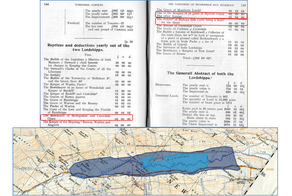
Foresters maintained and protected the forests and chases. As late as 1621, laws against hunting were still being enforced in Bishopdale: among those arraigned before the quarter sessions in Richmond that year were “A butcher of Niwbegin in Aiskarth, and two labrs of the same for breaking the King’s Park &c at Bushopdale, called Bishopdale Chase, and there shooting a doe younge with fawne with an arrow shot out of a crossbow”. A survey of the lordship of Middleham undertaken in 1605 recorded that the Bowbearer of Bishopdale and Coverdale Chase, the title by which the head forester was known, received an annual salary of £2 and that other employees of the lordship of Middleham included two other “keepers of ye game in Bishopsdale Chace” plus a “Paliser of Bishops dale Carre being a frith for the deare”. A frith was a protected deer park and a palliser was someone responsible for maintaining the fences of a deer park.
Seventy years earlier, in the 1530s, John Leland had referred to a “pretty carr or pool” in Bishopdale. The word ‘carr’ means swamp in Old Norse, so it seems that vestiges of the post-glacial lake in Bishopdale survived until the seventeenth century. The Carr originally stretched from below Hargarth Farm at the west end of Newbiggin to where Ribba Hall now stands (the area shaded dark blue), although by the 16th century, it had shrunk to the area shaded light blue with embankments at each end, parts of which are still visible. It was probably drained following the sale of Bishopdale Chase by Charles II in 1661.
The Medieval Road and Field Systems in Bishopdale
It appears that there were at least two open fields at Thoralby, the East Field and the West Field. Evidence for this can be found in the names of Eastfield Lane and Westfield Lane. Such lanes did not originate as means of travelling between villages, but to enable villagers to access their fields. The main routeway through Bishopdale in the Middle Ages was not the present road (represented by a broken red line on this early O.S. map), but one that followed the solid red line on the map, following Eshington Lane and Eastfield Lane, through Thoralby and out along Westfield Lane, continuing along what is now a footpath through Croxby and past How Syke and then following the route of the modern road from near New House and Ribba Hall up to the top of Kidstones Pass.
There is some uncertainty about the layout and extent of the open arable fields in Bishopdale, but most, if not all of the villages there followed a standard pattern comprising an East Field and a West Field. A rough approximation of the position and extent of these fields is shown on the map, with the East Fields being depicted in green and the West Fields in blue. One field was cultivated each year whilst the other lay fallow to replenish its nutrients. The lord’s demesne arable lands were usually scattered in strips in the common fields alongside those of their tenants, as shown in this diagram of a village with three fields, which I have used because I couldn’t find one with two fields. In addition to the open fields, there were meadows and pasture, including moorland grazing that was used mainly in the summer months. Meadows were divided into strips because a crop of hay was taken from them, but pastures were grazed in common. Sir Anthony Fitzherbert wrote in 1523 “Now the most part of the lords have enclosed their demesne lands and meadows, and keep them in severalty; so that their tenants have no common with them therein.” – from which one can infer that the lord’s desmesne lands in Bishopdale, which had become crown lands in 1483, were probably enclosed in the late Middle Ages, while the lands of the tenants remained as strips in open fields.

A Survey of the Lordships of Middleham and Richmond, 1605
A Survey of the Lordships of Middleham and Richmond in 1605 stated that ‘Bishops dale Chace’ in the lordship of Middleham consisted of six parts: Burton, Walden, Thorolby, Bishopsdale, Newbigging and Aisgarthe. It named all the tenants in each of these townships, and listed how many houses there were, how many outhouses (most of which would have been barns), how much meadow, arable and pasture and how many pasture gates or beast gates there were on the open pasture. The information is summarised in this table, which includes the annual rent paid to the king and the annual value. The numbers of tenants and houses show clearly that in the early 17th century Thoralby had twice as many tenants and almost twice as many houses as any other settlement in and around Bishopdale, although the figures for Aysgarth should be ignored because only part of the township was in Bishopdale Chase. In the whole of the lordship, Thoralby was second in size and value to Middleham itself. Perhaps the most significant figure is the amount of arable land, a total of 339¼ acres in Bishopdale Chase as a whole, which reflects the need for rural communities to be largely self-sufficient at that time. Most of the crops would have been oats, used to make haverbread and oatcakes, which formed the main element of the staple diet of dales folk at that time, but some vegetables would also have been grown to add variety to the diet.

Below is a table showing the names of the Bishopdale Tenants in 1605, showing houses,outhouses and lands, held, fines paid in the last 20 years, yearly rent to the King and the yearly value of things held. Transcribed from, Three Seventeenth Century Yorkshire Surveys, Editors: T.S. Willan & E. W. Crossley, published, 1941, pp.105-106. The original manuscript is in the possession of the Yorkshire Archaeological Society. Book, courtesy of the Dales Countryside Museum, Hawes.
The table is transcribed in the order it was published, which was not alphabetical. I do not know whether this order is significant or not, so if you wish to locate a particular surname, use the Search box in the table. The only surname from 1605, that is still in Bishopdale today is: Fawcett.
Totals for the above table are below, surprisingly there were 26 individual houses, in 1605, compared to around 15 today.
Cleare improvement £155 9s. 9.
Some Observacons concerning these two Lordshipps
Although the Lordship of Middleham was sold by Charles I to the City of London in 1628 to pay off some of his debts, there were several exclusions from the sale, including Bishopdale Chase, although the lordship of Thoralby was included in the sale. A further document entitled “Some Observations concerning these two Lordships” (the lordships of Middleham and Richmond), written sometime after 1628, provides some interesting glimpses of Bishopdale in the 17th Century. It states: “There are few or no woods or tymber trees in the two Lordshipps besides the woods growing in Radale, Bishops dale Chace & the Heaning.” This reminds us that the Forest of Wensleydale and Bishopdale Chase were not heavily wooded.
Another statement it made was: “The greatest part of these two Lordshipps consists of Medow and Pasture, ℓ Out Common, wth a small quantity of Arrable land, it being not able to beare Corne for ye coldness of the soyle and the length of winter there.” Fairly self-explanatory, but ‘corn’ in this sense means wheat. As I have already mentioned, oats, vegetables and probably a little barley were grown.
This statement reminds us that, until the end of Elizabeth’s reign, people everywhere in the north, including those in Bishopdale, were expected to provide military service to protect against marauding raids from Scotland. “That so often as occasion should require they should be ready to attend the Lord Wardens of the Marches against Scotland with horse ℓ men well furnished for warre at theyre owne charge as long as need should require…But this service ceased at the coming in of King James.” It will have been this requirement that led to the men of Bishopdale being involved in the Battle of Flodden Field I mentioned earlier.
It seems that enclosures had begun by this time because the document states: “The enclosures are most of them rich grounds ℓ lye all in the dales encompast wth mounteynes, moores and fells.” It is likely that the principal enclosures were near the village in the lordship of Thoralby, which the City of London sold in 1661 to a Major Norton, who lived near Richmond. Enclosures probably had more impact on how the dale looked and on how its economy developed than any other event since the Anglo-Danish settlements.
